PLANNING FRAMEWORK:
The Government of Alberta Municipal Government Act (MGA) provides the basis for statutory and non-statutory plans. An Intermunicipal Development Plan (IDP), a Municipal Development Plan (MDP), an Area Structure Plan (ASP) and a Neighbourhood Area Structure Plan (NASP) are all statutory plans under the MGA. These plans provide planning direction at a higher level and increase in detail progressively through the planning hierarchy to guide growth and development. The Tillotson NASP shall advance the planning work completed through the West Okotoks Area Structure Plan (WOASP) process and provide an additional level of detail.

PROJECT OVERVIEW:
The proposed Tillotson Neighbourhood Area Structure Plan (NASP) is a statutory plan that, upon approval by the Town of Okotoks Council, will provide a detailed framework to guide the development of approximately 159 acres of land situated within West Okotoks. The Tillotson NASP shall address the following:
- Community vision and guiding principles;
- Policy and regulatory framework;
- Plan area conditions, opportunities and constraints;
- Surrounding area conditions, opportunities and constraints;
- Residential land uses, density and projected population;
- Non – residential land uses, employment density and projected jobs;
- Open space network and conceptual programming;
- Pedestrian and vehicular circulation;
- Water, Sanitary and Stormwater utility servicing systems; and,
- Phasing of development within plan area.
At full build-out, Tillotson will accommodate a range and diversity of housing types and forms, a significant and interconnected open space network, a school site and neighbourhood hubs meeting the needs of both existing and future residents of Okotoks.


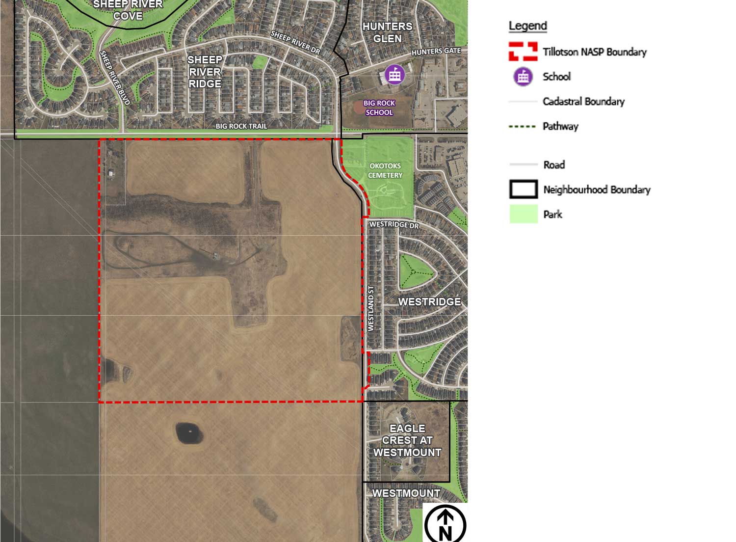
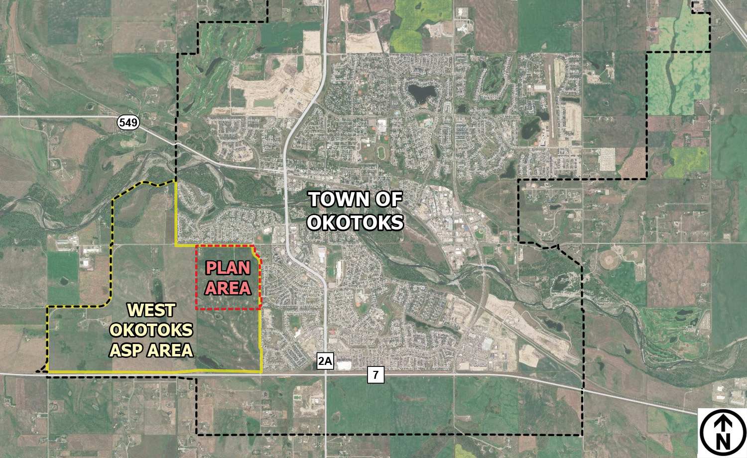
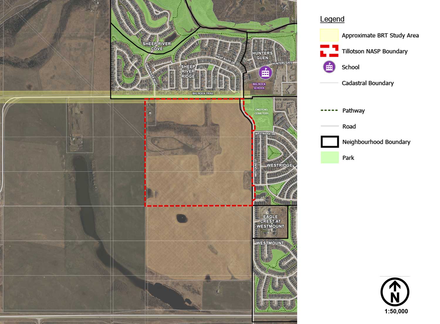
LOCATION & CONTEXT:
The Tillotson NASP plan area consists of approximately 159 acres of land situated within the southwest portion of the Town of Okotoks. The existing neighbourhoods of Westmount, Westridge, Sheep River Ridge and Sheep River Heights are situated immediately adjacent to the plan area and provide sensitive interface conditions that shall be addressed through the NASP planning process.
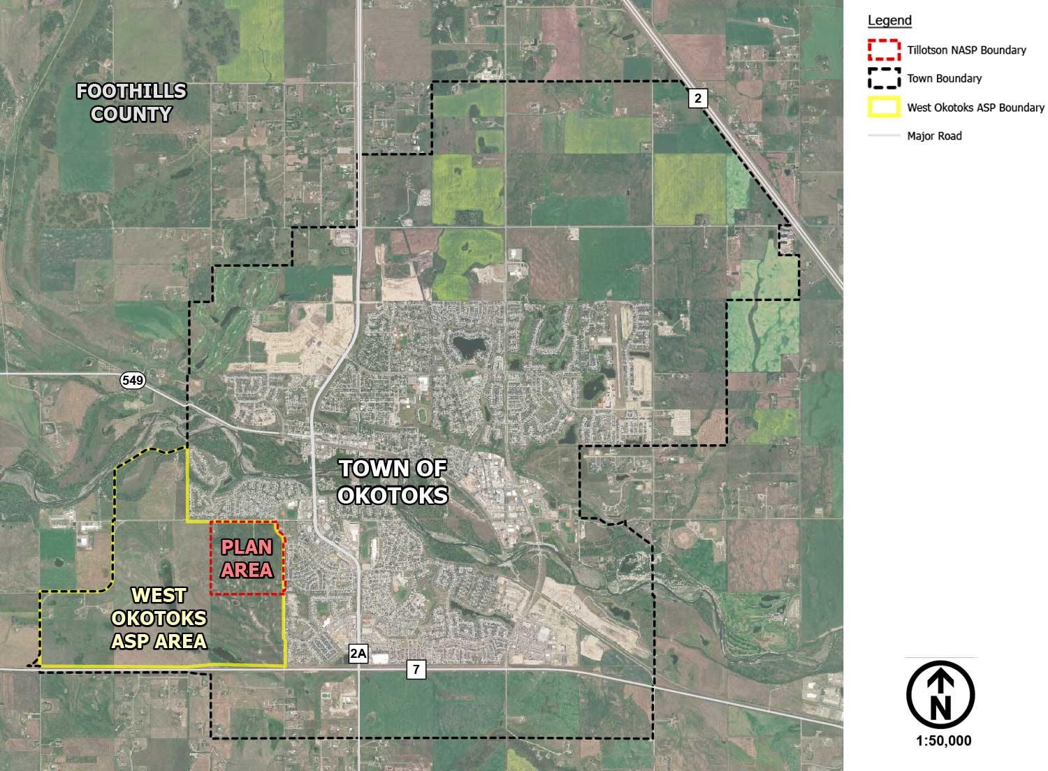
WEST OKOTOKS AREA STRUCTURE PLAN:
The West Okotoks ASP (WOASP) was adopted by Council on April 28, 2020, to guide the development of approximately 1,059 acres of land annexed to the Town of Okotoks in July 2017. The WOASP provides policy direction for more detailed planning stages, including subsequent Neighbourhood Area Structure Plans, Land Use Amendments and Subdivision applications. The Tillotson NASP plan area is identified as the first phase of development within the WOASP and will be the first of five future neighbourhoods within the WOASP area.
To learn more about the West Okotoks Area Structure Plan please visit http://www.westokotoksasp.com/
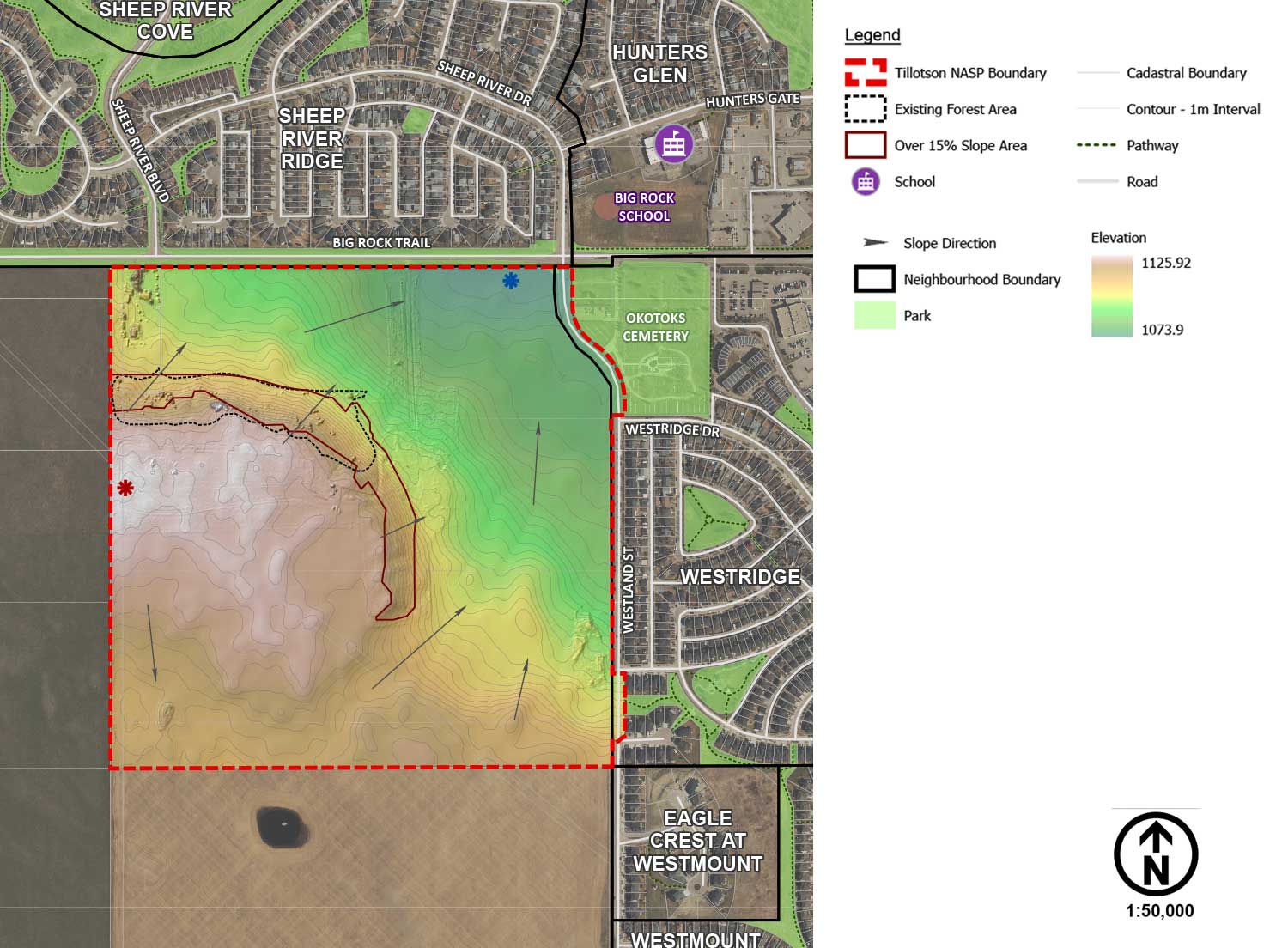
PLAN AREA CONDITIONS:
The preparation of the Tillotson NASP shall be supported by a range of baseline and technical studies and supplemented by feedback received through the stakeholder engagement. The following baseline and technical studies will support the development of the Tillotson NASP:
- Historical Resources Overview
- Phase I/II Environmental Site Assessments
- Biophysical Overview
- Desktop and Intrusive Geotechnical Assessment(s)
- Transportation Impact Assessment
- Water, Sanitary and Stormwater Servicing Reports
- Big Rock Trail Functional Planning Study (BRTFPS)
BIG ROCK TRAIL FUNCTIONAL PLANNING STUDY:
In addition to the required baseline and technical studies to support the Tillotson NASP, the Big Rock Trail Functional Planning Study (BRTFPS) is being undertaken by Watt Consulting Group in consideration of the Tillotson NASP.
The BRTFPS will identify the most appropriate design and phasing of upgrades of Big Rock Trail to accommodate growth. The study area spans between Southridge Drive and Township Road 203A, including the section directly north of the Tillotson plan area. The BRTFPS will:
- Document and detail the existing and future transportation conditions and function of BRT;
- Detail preliminary design concepts to meet future transportation conditions of BRT:
- Identify staging options and recommendations for phased improvements to BRT.
The results of the study and recommendations will be shared through future public engagement.
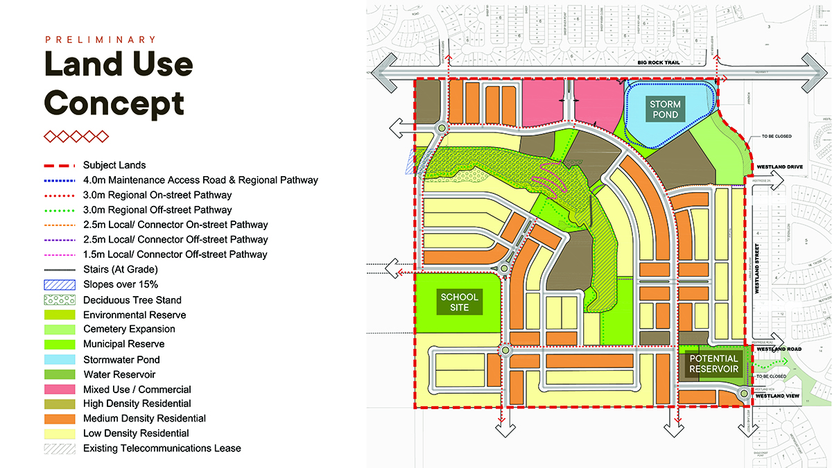
LAND USE CONCEPT
A Land Use Concept illustrates the general location of proposed land uses, streets and pathways, and open space areas. It provides a framework for how a community will be developed over time. The land use concept was informed by completed baseline studies, technical evaluation and feedback and review provided by the Town of Okotoks and other stakeholders.
Looking to stay updated on the Tillotson Neighbourhood Area Structure Plan?
Sign-up today to receive email updates regarding the Tillotson Neighbourhood Area Structure Plan process. Simply enter your information and check your email inbox for a confirmation email.